UAV MegaCam and Satcam Now Support Automatic Georeferencing and Image Mosaicing
Airborne Innovations imaging systems now feature automatic georeferencing, image mosaicing, orthocorrection, and realtime map mosaic display!
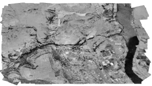
The system obtains aircraft data from a Piccolo UAV avionics or standard NMEA source via a secondary serial port. Aircraft metadata including GPS data and attitude are attached to the image, and the ground-based imagery application georeferences the images and displays and mosaics the georeferenced images on a map display as they arrive in realtime. The system outputs georeferenced images, aircraft metadata, and raw images for a high degree of flexibility.
An aircraft-view image simulator is also provided to test the system on the ground.

Automatic image mosaicing and georeferencing from an autonomous scanning flight plan with a Piccolo avionics.
(Click thumbnail for higher resolution)
Realtime image mosaic zooming capability:
Shockwave Demo
